heading east out of saskatoon was a bit like heading east into saskatoon…flat with green fields of farmed land…lots of
them. we had gorgeous temperatures, flat
lands and green farmed fields of corn, wheat, barley, sorghum, soybeans with numerous scattered lakes and marshes.
driving nearly 200 miles we
found a saskatchewan provincial park we thought look and sounded
nice. good spirit lake. we
have had really good luck with provincial parks in the canadian provinces, so
why not. another great choice. free firewood and showers, quiet for the most
part, even considering our nearing the last big summer weekend and a lovely
lakeside walk which gravy enjoyed probably more than we did.
 |
| good spirit lake |
that evening we sat around
the huge campfire we had and while looking at the map, decided to dip down into
the US, through north dakota and visit some pals of ours in minnesota and wisconsin instead of taking the one and only route through winnipeg and east.
we thought seeing old friends would be so much better than driving on a
busy highway in canada dodging semi’s and late summer tourists.
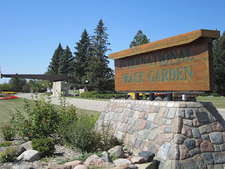
our border crossing took us through the international peace
garden, a 3.65 sq mile park straddling north dakota and manitoba devoted to world peace and a symbol of friendship. we only saw a small part of the garden as there are many lovely displays, gorgeous colorful flowers and even places to camp.
 |
| 7 peace poles at the int'l peace garden |
not far south of the border is the small town of rugby, north dakota, often billed as the geographic center of north america.
our mission was to visit a couple of friends in these northern states, but 1st we had to get there via beautiful farmlands in north dakota, minnesota and wisconson, cross the john blatnik bridge in duluth and pass some gorgeous dairy farms in wisconsin.
 |
| blatnik bridge over st louis bay and lake superior |
 |
| pulaski, wi church |
and finally we meet up with old pals....we got to have a nice picnic lunch with buffy from minnesota.
 |
| buddy and buffy, who we've known since our burundi days in the early 90s |
and more friends, the miller family, who live north of green bay, close to the shore of lake michigan...we stayed with lynn and jake and were lucky enough to see both of their gorgeous girls, hannah and haley, who happened to be home before college started.
 |
| haley, jake, lynn, hannah |
that quick weekend blast visiting old friends is just what we needed as we realized that we had not been inside a home (any home) since fairbanks, nor had we slept in a real bed since oregon! wow...
from there, we headed towards ontario, canada, driving north along lake michigan and into the upper peninsula of michigan before crossing into sault saint marie.
 |
| shores of lake michigan |
 |
| beautiful lake michigan |
we then traveled north into the up and crossed into sault saint marie with locks
 |
| soo locks--the busiest locks in the world, on the st. mary's river connecting lake superior to the other great lakes |
we headed through central ontario, and the greater sudbury area, with 2 of the largest smoke stacks we'd ever seen from their working nickel mines. the area was beautiful, but the air was another story.
 |
| sudbury's skyline...yikes |
we found a lovely campground in one of ontario's provincial parks along the shores of the ottawa river.
 |
| ottawa river--dividing ontario and quebec provinces |
 |
| in our campground--the leaves are beginning to change |
we decided to see some (key word!) of the next 3 LARGE cities (ottawa, montreal, quebec) we were about to stumble upon even though we designed this trip more to stay out of large cities ...we drove right through beautiful downtown ottawa and loved the historic feel plus the green belts on both the north and south ends of the city that skirts the ottawa river...
 |
| downtown ottawa |
 |
| ottawa river |
 |
| 4 way stop |
after leaving ottawa, we followed the ottawa river into quebec province. montreal is only 120 miles from ottawa due east and if you don't take the right turn, you will blast right through, right underground and pass completely through montreal. that's exactly what we did. the co-pilot was mapping out the route along the st lawrence river and the driver (no names mentioned here) was not watching his gps, so the underground route is the one we took. when we popped up on the north side of the city, that was it. city gone. montreal was behind us and we couldn't even see the skyline in our rear view mirror. so much for any narrative or photos of montreal...guess that'll be another trip!
but what we did catch on camera, all throughout the province, are the gorgeous roman catholic churches, everywhere...
a social call...camping with a new found friend of gravy's
we meandered up the st lawrence river then crossed onto the east side about 1/2 between montreal and quebec. our mission this time was NOT to pass right through quebec, but to take some photos of the old city from the eastern shores of the st lawrence river. this is what we saw...
 |
| the mighty st lawrence |
 |
| two lovely old women eating ice cream at 10am |
 |
| the bridge from quebec to the east side of the river |
 |
| levis, the small town on the east side of the river |
from this small town on the east side of st lawrence river we headed north to wind our way to the maritimes....


No comments:
Post a Comment